Milford or Piopiotahi Heritage - Avalanche Damage 1945, Homer Tunnel, Milford Road
Shared by Central & Western Murihiku Southland Archive
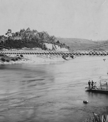
Milford or Piopiotahi Heritage - Avalanche Damage 1945, Homer Tunnel, Milford Road: After avalanche fatalities on the Homer Tunnel project in both 1936 & 37, in Sept 1945 the huge reinforced concrete protective shelter was destroyed by another avalanche. Fortunately, labour shortages due to WW2 had forced the work on this project to close, so no one was injured. After this, the completion of Homer Tunnel did not resume until early in the 1950s. IMAGES: 1 - Tunnel Portal, note covered area on right from workshop. Escape area on left from portal. 2 - Damaged Workshops 3 - Smashed Portal 4 - Crushed portal, avalanche Sept 1945. Jill (Stewart - later Duncan), 'Dad' (Herb/Herbert Stewart), Carley (later Burnby), and Reid (Stewart). THE PHOTOGRAPHERS - STEWART FAMILY HISTORY IN FIORDLAND The Stewart Family often ventured into Fiordland area, as father Herb was an electrician, working in days when electricity was being connected in out-of-the-way places. He was also to install the first electric lights at the Te Anau Caves! Herb would take the family along at times, so they would set up camp and go tramping whenever possible. Some of Carley Burnby's (nee Stewart) photos of trips up the Milford road when she was a teenager in the mid-1940s, are displayed here, showing the Homer Tunnel avalanche damage. More of these and other trips to Milford and surrounds to follow. Carley with her husband George and children, were the first family to settle at Knobs Flat in 1952 working for the Ministry of Works before moving to Cascade Creek in 1956. They then moved to Te Anau in time for the children to start school there. Also building one of the first accommodation places at Te Anau, they have a very long-standing history in Fiordland, Milford Road and Te Anau areas. There are a lot more entries in these CWA Community Archives online, about the Burnby Family and their history in the Fiordland area, with many more to come. So watch this space. HOMER TUNNEL AVALANCHE SHELTER HISTORY The Homer Tunnel sits at the head of a glaciated valley amongst mountains which tower around it, and these are up to 2100m in height. It provides the road only access link along the famous Milford Road, between Te Anau and Milford Sound. In the 1930's the original 150m avalanche protection shelter on the Te Anau side had a start made on its constructing. But this proved woefully inadequate, when an avalanche in September 1945 almost completely destroyed the shelter, with only 35m of it remaining. Limited protection against avalanches and rockfalls continued until recently, so finally the construction of a new avalanche shelter was made between March - June 2024. The job went to firm Cirtex. And the work was completed prior to the 2024-2025 season. This project had started back in 2022, with making improvements to the tunnel itself, then in 2023, the implementation of an underground works store. Demolition of the original shelter during 2023, and finally the installation of the new shelter during early 2024. In breaking news, the new avalanche shelter recently built at the eastern portal of the Milford Road's Homer Tunnel on State Highway 94 received "highly commended" honour for its outstanding engineering, resilience, and environmental sensitivity at the 2025 Concrete Construction Awards in Auckland, June 2025. More information can be found on this site in the Place Notes below. NEW AVALANCHE SHELTER DETAILS Taken from their website on the new avalanche protection shelter, they say: "As part of the design requirement behind the new shelter, an MSE wall on the uphill side will deflect any falling snow and debris over the shelter roof during an avalanche event. Located approximately 20km east of the Alpine Fault, the MSE wall also needs to account for high seismic demands. Under a magnitude 7.1 earthquake, as much as 61m of avalanche flow and debris could be deposited upon the shelter, imposing additional horizontal and vertical loadings on the MSE wall. A 36.6m long main wall and an 18m long approach wall were designed and constructed as two separate components using DuraMesh Panels reinforced with StrataGrid Geogrid. With a 100-yr design life, the main wall will be approximately 4.75m high and will taper where it meets the batter slope in front of the existing tunnel portal headwall, with the approach wall tapering to approximately 0.5m at the other end. The new shelter will consist of a reinforced concrete portal-framed roof structure built over the existing road, with the MSE wall constructed behind concrete facing panels on the upper side of the tunnel approach. Reinforced using extended StrataGrid lengths in 300mm lifts, the main MSE wall and reinforced concrete roof will be covered with site-won talus material to provide cushioning in the event of avalanches and rock falls." SOME EARLY MILFORD or PIOPIOTAHI ROAD HISTORY: Māori named Milford Sound, Piopiotahi, which is said to mean “a single piopio”. Māori belief is that when their legendary hero Maui died trying to win immortality for his beloved people, a piopio (a now long-extinct native bird) was said to have flown here in mourning, so that is their name for it. The earlier Milford Track was created thanks to the first permanent settler in Fiordland, Donald Sutherland and a friend, as well as Quintin MacKinnon. Donald was to discover what he named the 'Sutherland Falls', on 10 November 1880, and these became the highlight of Milford, with many clamouring to see them. Sutherland and MacKinnon were later, separately commissioned to work on different parts of the route and their combined successes, some easier and some hard won, formed the original Milford Track and opened up the Milford area to what would later become the famed Milford Road. After early private forays into the industry, Milford Tourism was taken over by the Government and their Tourist Bureau. What really put the Milford Track on the map, was the opening of the long awaited Homer Tunnel. From a route being found back in 1910, it took around 40 years to become a reality. From 1929 when the first work party staring on forming the road, which would include the tunnel, to 1940 when the tunnelers finally broke through, it was the 1954/55 season before private cars were able to use the new Homer Tunnel. However, along the way, the Homer Tunnel was subjected to some very destructive avalanches and loss of lives and infrastructure from these. After the first avalanche in 1936 and another around 12 months later in 1937, which both caused fatalities, there was another one in September 1945 shown above, which tore the heart out of the protective shelter. This was meant to save the area from the risk of avalanches. The workshops were totally destroyed and the shelter mostly destroyed. It was never rebuilt until recently, with the road having to be frequently closed from risk of avalanche or the aftermath of them. Luckily, due to labour shortages from WW2, the project was closed at the time, so no lives were lost this time. In their history of the Homer Tunnel and Milford Road, Engineering NZ tell us that the surrounding Upper Hollyford and Cleddau Valleys are really great examples of glacial formation and have almost vertical 800m high walls, and above these are vast areas of snowfields up to 2,500m elevation. So, when combined with heavy snowfalls, it makes these valleys particularly prone to avalanches. The most dangerous are dry avalanches and these occur when it is snowing on the tops. Being noiseless right up until suddenly a powerful compressed air blast occurs upon landing, there is little warning for people to get out of their way. Sadly, in July 1936, Percy Leigh Overton, 26-year-old tunneler was killed and several other men injured when an avalanche was to engulf the tunnel’s entrance. After this event, a reinforced concrete shelter was built out from the tunnel mouth, in an attempt to provide protection for the tunnel workers. But, this did not prevent further fatalities and injury. PWD or Public Works Department Engineer-in-Charge, Donald Frederic Hulse, appointed after the 1936 avalanche, was then killed alongside Thomas W Smith, the tunnel works overseer, near the tunnel entrance by another avalanche around 12 months later, in 1937. At that time, around 20 men were working outside the tunnel with another 20 odd men engaged on the tunnel works inside. Following the avalanche events, workers were pulled out until Downer and Company Limited picked up the tunneling contract the following summer. For safety reasons, works stopped during the winter of 1938 as well. And after that, the advent of WW2 was to also severely hamper tunnel works. Thanks to Engineering NZ for fully supporting our heritage project and allowing us to use their material in our online CWA Community Archives. So these ongoing delays and costs blew out the projects finances severely. The closures of the works from events such as avalanches and WW2 also took a toll with delays in the time taken to complete the tunnel project. The total of the extremely long tunnel project had come to over $1 million, after an initial quote by the Public Works Department of £2,000 back in 1890. When the tunnel was completed, you entered it on the Hollyford side where it sat at 3,023 feet or 921 m above sea level, and 3/4 of a mile or 1.2 km long and had a grade of one in ten, where you come out of it on the Milford side. The newly constructed avalanche shelter has been made with unique local iwi artworks embedded into the front of the concrete. As the Milford Sounds is one of Aotearoa New Zealand's most visited spots for tourists, both international and national, we should all spare a thought for those enterprising explorers who found this place, and for those who worked long and hard, in difficult and dangerous conditions, often by force on unemployed labour work parties, to make road access possible, some even losing their lives. The risk remains and sometimes the road is still closed in avalanche weather. But the astounding views, especially of the famed Mitre Peak or Rahotu, make this long trip worthwhile. Mitre Peak was was named by Captain John Lort Stokes of the HMS Acheron, who saw the shape of it as similar to the mitre headwear of Christian bishops of the time. The Māori name for the peak is Rahotu, and it sits at 1683m of grandeur. VISITING IN THE CURRENT DAY: Milford Sounds visitor site tells us, "Milford Sound is located in a remote part of the South Island, with only one road leading to the world famous fiord. The Milford Road is not just a way to get to Milford Sound. It’s an unforgettable journey into the heart of Fiordland National Park. There are several ways to get to Milford Sound, including bus and coach travel, self-drive or air travel. The method you choose will depend on the amount of time you have, your budget and what type of traveller you are." For more information on this site, see the Place Notes below. Archivists comment: At the CWA Community & Heritage Hub, operated by Central & Western Archive - Murihiku Southland, we have books, records and photos on the history of this area, bush, mountains, tracks and more. Hopefully this entry will be added to as more information on the history comes to hand. If you or anyone you know has any more information or photos to share or accounts of Homer Tunnel, the Milford Road, or the wider area of Fiordland or Te Rua-o-Te-Moko, please do share this with us in the comments section. You can do this by making a comment in the space provided under the image page. Or you can make contact with us as per the archive front page.
Ngā whakamārama
Details
-
Title
Milford or Piopiotahi Heritage - Avalanche Damage 1945, Homer Tunnel, Milford Road
-
Maker
Unknown
-
Date made
after September 1945
-
Subject
Fiordland, Te Rua-o-te-moko, Western Southland, Great outdoors, Fiordland National Park, Outdoor Adventure, Mountain Tops, Milford Road, Early Exploration, Early Travel, Tourism, Avalanches & other Hazards, Homer Tunnel, Milford Sound, Piopiotahi, Aoteroa NZ, Burnby Family, Stewart Family, Electricity Installation
-
Additional information
Digital only image in archive
-
Rights
Attribution (cc)
http://creativecommons.org/licenses/by/4.0/ -
View source record for this item
Kei hea tēnei taonga?
Where is this item held?
-
Additional information including high resolution images may be available.
-
Location
Main Rd, Tūātapere, next to the old Railway Station. We also belong to the internationally recognised 'Safe Space Alliance'.
Whare taonga | Organisation
Central & Western Murihiku Southland Archive
Ngā here ki runga i ngā whakaahua o tēnei taonga?
What can you do with images of this item?
-
You must check with Central & Western Murihiku Southland Archive to confirm terms of use and any attribution requirements, but this is our understanding:
-
Use for private study, research, criticism, review, or education
NZ Copyright law allows for the use of copyrighted works in specific circumstances. Consider what you can do under copyright law.
-
Share
You can share this image without further permission.
-
Modify or remix
You can modify, remix or add to this image without further permission.
-
Commercial use
You can use this image to make money.
-
Text adapted with permission from Te Papa and Digital NZ
Tāpirihia he kōrero anō
Improve this record
-
Can you help us? Share names, details and stories to help enrich the collection.