Fiordland or Te Rua-o-Te-Moko, Natural Heritage - Lake Browne & Browne Falls
Shared by Central & Western Murihiku Southland Archive
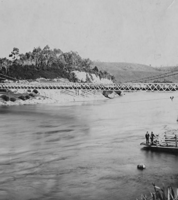
Fiordland or Te Rua-o-Te-Moko, Natural Heritage - Lake Browne & Falls First Photo, Lake Browne with Browne Falls 2025, within the Fiordland or Te Rua-o-Te-Moko National Park. One of thousands of natural heritage sites within that, this shows a really amazing vista of the lake, which sits nestled into the top of the mountains surrounding it. Lake Browne is the outlet for the Browne Falls, which are reputed to have the highest drop of any waterfall across Aotearoa NZ. This is a very appropriate photo for an aviator! The amazing image shown here was taken by Wings & Water, and kindly shared with us to present Lake Browne & Browne Falls. Reproduced here with permission. (C) Please note: this image is under copyright. The photographers who are Wings & Water owners/operators Kylie and Ivan Krippner, have owned this particular business since 2015 and are really passionate about showcasing Fiordland. Both the lake and falls are named after V C Browne the aerial photographer whose work has helped generations of trampers to more safely explore the area, and to personally discover these previously unknown parts of Fiordland or Te Rua-o-Te-Moko for themselves. Interestingly, float planes have been operating on Lake Te Anau since 1962 say the Krippner's. You can read more about them and their 'Fiordland by Seaplane' services from the link listed in the Place Notes below. Second Photo, an earlier image which is very similar, but from many years prior, in 1950. Thus one was taken by VC Browne, who discovered the Lake and Falls. The photo caption reads: "Looking WSW over Fergusson Island, Doubtful Sound to Lake Browne and Browne Falls. Crooked Arm just visible centre top." This image is under Copyright to VCBrowne.com and the original image of this can be found in the VC Browne online collections, here: https://www.vcbrowne.com/Detail3.aspx?RID=WK60-108&PID=88&Caller=Search Used here with permission. See more information about VC Browne below. VC Browne's obituary was in The Press news on 18 September 1980. Victor Carlyle Browne, pioneer in NZ aerial photography had died, aged 80. He was to discover two Fiordland lakes during 1938, on his photographic flights. One of the lakes was named after him, while the other was given the name of Lake Chamberlain. He was also to discover the Browne Falls, which of course fall from Lake Browne, and these are both shown here. In 1979, he was honoured by Canterbury Aero Club with a life membership, the first non-flier in the club's history to be granted this. He had flown as an aerial photography passenger for 45 years, and gained respect for his work across the country. The club's vice-president said at the time, "Nobody has photographed New Zealand as extensively as Vic Browne." For years 'The Press' printed his photos and several books of his works were published. In 1925 he arrived in Christchurch to take photographs for 'New Zealand from the Air, a pioneer publication of its time. During this project, he and Captain Bradshaw flew over the whole country, from Stewart Island to North Cape. But his crowning glory was, 'The Coast: A Pictorial Exploration,' published in 1962. After he retired, the Browne name continued when he handed his well-established business over to son, Bill. The VC Browne photographs that he took are now available in an online site like ours, the address to view these is also in the Place Notes below. SITE HISTORY: The Browne Falls, named after Victor Carlyle Browne, who discovered Lake Browne and associated waterfall descending from this, on his flights over Fiordland or Te Rua-o-Te-Moko. Situated high above Doubtful Sound, it is thought by some, that the Browne Falls may be the highest waterfall in Aotearoa New Zealand. They descend 836 meters, and are only accessible via a cruise or flight into Doubtful Sound. The falls descend in a series of sections, cascading for a distance, before disappearing behind rocks and trees then once again reappearing, much to the delight of onlookers. EARLY DISTRICT HISTORY: Patea or Doubtful Sound, according to the Fiordland National Park Board book, 'Fiordland National Park' written by Gerard Hall-Jones was named after Captain Cook's first voyage here in March 1770, as the wind there was 'doubtful'. Patea or 'place of silence' was the name Māori gave to it. Fascinatingly, Cook and his crew, including scientists, tried to land, but never made it. So without setting foot on the soil, they left an indelible mark on the land, with naming it from issues with their early journey here. John Hall-Jones, in his 'Fiordland Explored' says while Captain Cook had named the now Doubtful Sound, the first Europeans to sail down it were the Spaniards, but under the command of an Italian, Alessandro Malaspina. Gerard Hall-Jones continues the story, telling us that next to visit were the Malaspina's commanded two Spanish ships, also carrying scientists, who also failed to land, but his name also remains, along with other Spanish ones. Sending out a longboat with Don Felipe Bauza in to map the area, and a copy of this in John Hall-Jones' book shows fabulous detail. But they could not get past Breaksea Island, so returned and headed for Sydney. Both the Hall-Jones' works go into more detail of the next part of the story. After this, during the sealing and whaling days, several stations were set up in the Sounds. One of these was Captain Grono (he now has a Bay named after him) who operated the ship 'Governor Bligh' out of Patea or Doubtful Sound. Captain John Grono has been termed the 'name-giver' according to John HJ, who covers the exploration and later naming of much of Patea or Doubtful Sound by Grono, whom he refers to as a "sturdy Welshman" and the first European to fully explore the Sound. Many of his names remain. But no more work was done to survey the Sounds until Captain JL Stokes came with the HMS Acheron, for their 1851 survey of the South and West Coasts. The diary notes of this survey are fascinating as an early look into the settlement of remote places, and some of these can be found at places like the Hocken Library in Ōtepoti Dunedin, and at National Library of NZ. It is interesting to note that features of the maps made from this survey, have remained in common use until late into the 20th Century, when modern mapping technologies have taken over. But copies of the early maps remain and some of these can be seen in John Hall-Jones' books on the area. STATISTICS: There were 641,600 visitors logged by the Fiordland regional tourism organisation in 2023. Many stay in the area en route to Milford Sound. Some choose to stay outside of Te Anau in the smaller, cosier Manapōuri. There are no permanent settlements in the Sounds (Fiords), but there are hiking huts on most walking tracks and also hunting huts in many places. Archivists comment: At the CWA Community & Heritage Hub, operated by Central & Western Archive - Murihiku Southland, we have books, records and photos on the history of this area, lakes, mountains, tracks and more. Hopefully this entry will be added to as more information on the history comes to hand. If you or anyone you know has any more information or photos to share or accounts of Lake Browne and Browne Falls, Patea or Doubtful Sound, Motu-rau (Lake Manapōuri), or the wider Fiordland or Te Rua-o-Te-Moko area, please share this with us in the comments section. You can do this by making a comment in the space provided under the image page. Or make contact with us as per the archive front page info.
Ngā whakamārama
Details
-
Title
Fiordland or Te Rua-o-Te-Moko, Natural Heritage - Lake Browne & Browne Falls
-
Maker
Wings & Water - Kylie and Ivan Krippner
-
Date made
2025
-
Subject
Fiordland, Te Rua-o-te-moko, Western Southland, Great outdoors, Fiordland National Park, Outdoor Adventure, Sports & Recreation, Kiwi Holidays, Patea or Doubtful Sound, Browne, VC - aerial photographer, Fiordland Sights & Wonders, "Fabulous Fiordland" Natural Heritage, Tourism, Fiords, Whaling & Sealing, Discoverers & Surveyors, Murihiku
-
Additional information
Digital only image in archive
-
Rights
All rights reserved
-
View source record for this item
Kei hea tēnei taonga?
Where is this item held?
-
Additional information including high resolution images may be available.
-
Location
Main Rd, Tūātapere, next to the old Railway Station. We also belong to the internationally recognised 'Safe Space Alliance'.
Whare taonga | Organisation
Central & Western Murihiku Southland Archive
Ngā here ki runga i ngā whakaahua o tēnei taonga?
What can you do with images of this item?
-
You must check with Central & Western Murihiku Southland Archive to confirm terms of use and any attribution requirements, but this is our understanding:
-
Use for private study, research, criticism, review, or education
NZ Copyright law allows for the use of copyrighted works in specific circumstances. Consider what you can do under copyright law.
-
No sharing
You can't share this image without futher permission.
-
No modifying
You can't modify, remix or add to this image without further permission.
-
No commercial use
You can't use this image to make money.
-
Text adapted with permission from Te Papa and Digital NZ
Tāpirihia he kōrero anō
Improve this record
-
Can you help us? Share names, details and stories to help enrich the collection.