Te Anau & District Heritage - Views of Lake Te Anau from the 1950's
Shared by Central & Western Murihiku Southland Archive
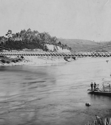
Te Anau & District Heritage - Views of Lake Te Anau from the 1950's, taken by Doug Fowle of Clifden, on a trip to Fiordland with the Erskine Family: 1 & 2 - Blue Gum Point, Lake Te Anau 3 & 4 - Boats on the water, Lake Te Anau 5 & 6 - With the same collection, but not sure these two are Lake Te Anau, can anyone else comment on this? Doug is no longer able to see very well. Taken in the early 1950's when Te Anau was not yet built up, these photos show quite a different view of the village than we can see now in 2025. SOME EARLY HISTORY: The wider district was surveyed early on by the Chief Surveyor of Otago, JT Thomson. Initially when he first saw Lakes Te Anau and Manapōuri in 1857, he had called them North and South Lake Te Anau and sketched them as such in his notes. He then passed over the job of continuing exploration to James McKerrow, whose original survey here started in 1862. JT Thomson's descendant, John Hall-Jones, in later writing his Fiordland Explored history, says he went up the same route as his great grandfather, to see how he could have made this assumption about the lakes, and found that you could indeed see the two bodies of water from that vantage point and it was not clear from there, these were two separate pieces of water. William Anderson in his Milford Tales, covers how the Te Anau area was adjacent to a virtually undiscovered wilderness, prior to MacKinnon Pass being found. That was well and truly reversed as the town became the centre of the highway into Milford, many years later. He notes how even proponents of the township were blown away by the sheer amount of tourist traffic coming their way. Te Anau itself was first surveyed in 1893, which was not long after the Milford Track opened. The township we know now, only developed as a tourist resort after the opening of the Homer Tunnel which allowed a traffic route into Milford in 1953. STATISTICS: Lake Te Anau is the true source of the Waiau River. The Upper Waiau River flows from here into Lake Manapōuri and onwards from there until it reaches the Waiau River Mouth, in Te Waewae Bay. Lake Te Anau at 348 sq km is Aotearoa New Zealand’s second largest lake. It is situated 212 metres above sea level, is 61 km long and its deepest point is 276 m. It has three fiords, these are boringly named as South, Middle and North Fiord. The eastern shore of Lake Te Anau is the start of the Murihiku Southland Plains. The western shoreline of the lake can reach 1,700 mm of rain each year, while the eastern side only has around 1,100 mm. Glow-worm caves lie on the west side, these are situated between the middle and south fiords. Te Anau lake is home to both trout and land-locked salmon. Te Anau township had a population of 1,911 in 2013. There were 641,600 visitors logged by the Fiordland regional tourism organisation in 2023. Te Anau is on the way to Milford, so many national and international tourists pass through it, and most of these would stop, even if just to fuel up their vehicles. Many stay en route to Milford Sound. It is a busy place in summer, although in winter there are motels and hotels who offer rooms at a reduced rate, while many restaurants close over the off season. On warm summer days the lakeside car parks are full and the town is buzzing, with boats galore out on the water and the grassed areas full of families and couples, tourists and locals alike, soaking in the sun. A huge array of accommodation options are available, from backpackers to luxury lodges and everything in between. A Bird Sanctuary is also popular. To learn more about visiting or staying in the town or district and the many attractions available, see the Place Notes below. Archivists comment: At the CWA Community & Heritage Hub, operated by Central & Western Archive - Murihiku Southland, we have books, records and photos on the history of the lakes, bush, mountains, tracks and more. Hopefully this entry will be added to as more information on the history comes to hand. If you or anyone you know has any more information or photos to share or accounts of Te Anau township, the lake or the wider Te Anau area of Fiordland or Te Rua-o-Te-Moko, please do share this with us in the comments section. You can do this by making a comment in the space provided under the image page. Or you can make contact with us as per the archive front page.
Ngā whakamārama
Details
-
Title
Te Anau & District Heritage - Views of Lake Te Anau from the 1950's
-
Maker
Fowle, Douglas (Doug)
-
Date made
1950's
-
Subject
Fiordland, Te Rua-o-te-moko, Western Southland, Great outdoors, Fiordland National Park, Outdoor Adventure, Te Anau, Te Anau Tourist Traveller, Lake Te Anau
-
Additional information
Digital only image in archive
-
Rights
Attribution (cc)
http://creativecommons.org/licenses/by/4.0/ -
View source record for this item
Kei hea tēnei taonga?
Where is this item held?
-
Additional information including high resolution images may be available.
-
Location
Main Rd, Tūātapere, next to the old Railway Station. We also belong to the internationally recognised 'Safe Space Alliance'.
Whare taonga | Organisation
Central & Western Murihiku Southland Archive
Ngā here ki runga i ngā whakaahua o tēnei taonga?
What can you do with images of this item?
-
You must check with Central & Western Murihiku Southland Archive to confirm terms of use and any attribution requirements, but this is our understanding:
-
Use for private study, research, criticism, review, or education
NZ Copyright law allows for the use of copyrighted works in specific circumstances. Consider what you can do under copyright law.
-
Share
You can share this image without further permission.
-
Modify or remix
You can modify, remix or add to this image without further permission.
-
Commercial use
You can use this image to make money.
-
Text adapted with permission from Te Papa and Digital NZ
Tāpirihia he kōrero anō
Improve this record
-
Can you help us? Share names, details and stories to help enrich the collection.