Western Southland District Heritage - Motorbike Tour, Southland Trip 1989-90
Shared by Central & Western Murihiku Southland Archive
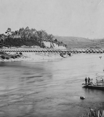
Western Southland District Heritage - Motorbike Tour, Southland Trip 1989-90: We were very fortunate to be donated a lot of old tourist slides and photos of Western Southland or Murihiku as well as the Fiordland or Te Rua-o-Te-Moko areas and heritage sites within these. These ones are a collection of scenes from a 1989-90 motorcycle trip, and photos from other years by the same person are can also be seen in these online Community Archives. IMAGES: 1 - Lake Hauroko, the deepest lake in Aotearoa NZ at 462m 2 - Clifden Suspension Bridge, Clifden, Waiau, opened 1899 3 - On the road to Cosy Nook, South West Coast 4 - At Cosy Nook, South West Coast These photos were all taken by Beau Hutton and are licensed CC BY. They appear dark so it is highly likely they have been taken into the setting sun, as all these places face west. The photos are also discoloured from age. SOME EARLY HISTORY: The wider district was briefly surveyed early on by the Chief Surveyor of Otago, JT Thomson. He then passed over the job of continuing exploration of the area to James McKerrow, whose original survey started in 1862. At this time, with two assistants, they were to observe wondrous views of what they termed Lake Howloko (Hauroko) and the then mighty Waiau River, which they crossed on more than one occasion. Tragically, one of those ending in the drowning of one of Clifden Estates station hands. It is probably lucky for the surveyors that they only saw the lake from a good distance, as this place is renown for large swarms of namu or sandflies. It was 1899 before the Waiau was bridged at Clifden, with a fine example of a suspension bridge (shown in the photo above) designed by C H Howarth. In keeping with the sad drowning mentioned earlier in this account, it was said the construction workers had difficulty slinging the required 28 bridge cables over the Waiau, which was well known and feared for carrying a large volume of water, being extremely fast flowing, and furious in flood. In 1978 this bridge was replaced by a new concrete one, still in use today. The old suspension bridge & reserve was gifted to Pouhere Taonga, Heritage NZ. Further down the coast at Cosy Nook, featured in the later photos in this series above, this place is significant to both Māori and Europeans as a settlement site of their people. Originally named Pahi after the Ngāi Tahu Chief of the same name, it was one of the earliest settled villages of Māori in the district and a sizeable one too. As well as this, the place was a well-known trading post for the two peoples to connect and exchange goods. The first European settler there was said to be the Harbourmaster from Bluff, one George Thomson, and he named the place he lived after the village he grew up at in Scotland, Cosy Neuk - which morphed into Nook. The settlement now houses a few holiday cribs (baches) and fishing boats. To learn more about visiting or staying in the town or district and the many attractions available, see the Place Notes below. Archivists comment: At the CWA Community & Heritage Hub, operated by Central & Western Archive - Murihiku Southland, we have books, records and photos on the history of the lakes, bush, mountains, tracks and more. Hopefully this entry will be added to as more information on the history comes to hand. If you or anyone you know has any more information or photos to share or accounts of Te Anau township, the lake or the wider Te Anau area of Fiordland or Te Rua-o-Te-Moko, please do share this with us in the comments section. You can do this by making a comment in the space provided under the image page. Or you can make contact with us as per the archive front page.
Ngā whakamārama
Details
-
Title
Western Southland District Heritage - Motorbike Tour, Southland Trip 1989-90
-
Maker
Hutton, Beau
-
Date made
1989-90
-
Subject
Fiordland, Te Rua-o-te-moko, Western Southland, Great outdoors, Fiordland National Park, Outdoor Adventure, Motorcycle Touring, Clifden Suspension Bridge, Cosy Nook, Lake Hauroko, Tūātapere, Southern Scenic Route, Highway 99, Off the beaten track
-
Additional information
Digital only image in archive
-
Rights
Attribution (cc)
http://creativecommons.org/licenses/by/4.0/ -
View source record for this item
Kei hea tēnei taonga?
Where is this item held?
-
Additional information including high resolution images may be available.
-
Location
Main Rd, Tūātapere, next to the old Railway Station. We also belong to the internationally recognised 'Safe Space Alliance'.
Whare taonga | Organisation
Central & Western Murihiku Southland Archive
Ngā here ki runga i ngā whakaahua o tēnei taonga?
What can you do with images of this item?
-
You must check with Central & Western Murihiku Southland Archive to confirm terms of use and any attribution requirements, but this is our understanding:
-
Use for private study, research, criticism, review, or education
NZ Copyright law allows for the use of copyrighted works in specific circumstances. Consider what you can do under copyright law.
-
Share
You can share this image without further permission.
-
Modify or remix
You can modify, remix or add to this image without further permission.
-
Commercial use
You can use this image to make money.
-
Text adapted with permission from Te Papa and Digital NZ
Tāpirihia he kōrero anō
Improve this record
-
Can you help us? Share names, details and stories to help enrich the collection.