Wallace County Infrastructure - Tūātapere Punt Crossing the Waiau, pre 1911
Shared by Central & Western Murihiku Southland Archive
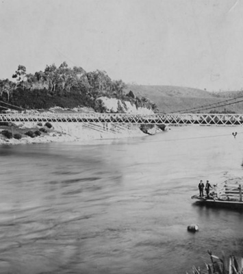
Wallace County Infrastructure - Tūātapere Punt Crossing the Waiau, pre 1911. Photo labelled as: "One of the punt ferries which plied the Waiau prior to the Bridge opening in 1915." This was gifted as part of the Margaret Thomas Collection, and the photo is in the Public Domain. From comparing other photos we hold, we believe Charles Rask is the puntman here, and that the gentleman in a suit at the front, is Hugh Erskine. There are also buildings shown on the opposite river bank. We know this photo is pre-1911 as there is no Tūātapere Dairy Factory yet. And the bush line on the western side of the Waiau is right by the river. HISTORY: Tūātapere has always been unfortunate in being built on two sides of the mighty Waiau River. In it's early days, what is now the township area was most often called 'Drummond's Ferry,' on account of the ferryman named Drummond, who operated the Government punt here for quite some time. History tells us that the township of Tūātapere used to sit between Te Tua and the Waiau or Drummond Ferry. The only crossing for many decades at Tūātapere, was by a river punt, such as that shown in this photo above. In 1896 "Bill" or William West was the ferryman at Clifden until 1899 when the Suspension Bridge at Clifden was opened. More can be seen about the Clifden bridge and the puntmen employed there over the years, in this archive, under entry CWA.001.010.002 The couple then moved, along with a new punt built by Bill, to what is now known as Tūātapere, but at that time it was also known by various names, West Waiau, Ryans Island and most often Papatotara. The change in name is explained thus in the Cyclopedia of Otago & Southland: "...long known by the name of Papatotara... when this name was bestowed on a settlement about six miles from the punt, towards the mouth of the Waiau river, on its western bank, it was deemed advisable to rename the district when the post office was established, on the Ist of January, 1904, and the name chosen was Tuatapere." We now know that the pronunciation of the name requires tohutō or macrons, and this makes it correctly written as Tūātapere. We know from early records that the punt at what was then called Papatotara, was under Government Contract to William or Bill West, who was referred to as, "The proprietor of a hotel on the western bank of the Waiau". That would have been his house, 'Angler's Rest'. Bill West employed Robert Drummond to operate the punt and for a time, the landings where Tūātapere is now, were also known as Drummonds Ferry. We find the story in early accounts of the area, that "Bob" Drummond was given the job of ferrying the punt and looking after the boats and it was this that led to the name of 'Drummond's Ferry', even tough the punt was operated by W. West, the owner of the 'Angler's Rest'. The punt was the only way settlers and travellers had to access the area west of the Waiau, and what is now known as Papatotara. It is most likely that the people shown in the buggies in the photo above, would be residents of the Papatotara Settlement, and likely some at least would be Erskine's as it appears that Hugh Erskine is at the front. It is said that early Tūātapere grew up around the 'ferry' which is what most people referred to the punt as, with the hotel being built first and more other buildings later. The Puntman after "Bob" Drummond, has been recorded as being C Rask, who we believe to be in this photo. Early district history, from FWG Miller’s, “West to the Fiords” account, tells how the punt was the most important feature in the district, with the life of the area depending on it. It was the only way for residents or workers on one side of the river to communicate with and access the other side. Miller tells of the time when there was 10 o’clock closing (of the pubs) and a great rush to get the final ferry of the day would ensue. Apparently on the odd occasion a special signal would be given to the ferryman to collect a late customer as well. However, often the drinkers would be stranded on the riverbank, which made for some some "miserable nights". And a similar story is also repeated in Des Williams, 'Hole In The Bush book', by Hugh McFeely where a piece is quoted that he was told Tūātapere means "standing and waving", but he rightly says there is no way of knowing if this is correct or not, but it's certainly a good story and a pun on the punt! The 'West to the Fiords' account of Miller's, concludes with an explanation of how the sawmills were also the cause of the most of the punt traffic, with many loads per day of timber carted over the Waiau River in season. In the news of the day, we find that in the years before the bridge was put across, the punt would do approximately 90 trips a day, sometimes more, with much of that being in loads of logs from the many sawmills. It appears as if the punt used to operate around the clock or pretty much 24/7, as we find that initially the punt hours were cut back to 16 per day. The amount of traffic using the punt sounds quite ridiculous and it was. Apparently often horses and carts would be backed up, so it was a big time waster to the industry and those needing to go to town, and is was very inefficient. Something had to be done. A bridge committee was set, up and they set to work on canvassing government. But more can be found about them in another entry in the archive with a photo of them. Of course the government was not happy either, about the huge costs of maintaining the punt with this much traffic, especially with a bridge being demanded by the locals. So it seems that not much has changed in the last 100 odd years! Then in their infinite wisdom and in a effort to cut costs, the local council decided to cut the punt hours, from 16 hours a day, down to just 10 hours! You can just imagine the reaction that got... From a report near the end of 1913, we hear that after the WCC decided earlier in year to cut the hours of the punt from 16 to 10 per day, a local councillor called Horrell, had said this action would “cause a riot”. At the current meeting, another councillor asked “if the riot had occurred yet!” Funnily enough Councillor Tapper said that on instruction from the WCC to report back on the punt service at their last meeting, he had actually ended up attending a near riot and entirely “stormy” gathering about this very matter at the township, recently. Southland Timber Yards and Sawmill Workers Union said the cut in hours was making it difficult for their members who worked across the river, as they could not get into the town and back by the time of the last punt. Lodge Waiau IOOF also said their numbers were being inconvenienced of the benefits of their membership, and those that this very lodge had been established to give them. So there were a lot of unhappy residents here. The meeting was told that those there would be happy to get the present cut of 10 hours back up to 12 hours 6 days a week, most especially as the current stop time on the punt was 8.15pm and so this precluded anyone being able to attend night-time meetings in the town, unless they lived on that side. It was not advocated to extend the Sunday hours any further as it was in this shut-down period of 3 hours that the ferryman could undertake any repairs to the punt as necessary. But in saying all this, it was also kindly noted, that no-one from the farming community was even there to establish how this would affect them, if differently. It would cost an extra £1 a week for the 2 hour extension according to the Engineer. Councillor Horrell thought going up to 12 hours was enough, but unfortunately the meeting had called for a return to the previous 16 hours or nothing. So this was not achieved. It was many years from the first bridge idea, to get anything happening. And then there were the breakdowns and breaking away's. In early 1913, Rev McEwen one of the ferry passengers on a certain trip, received a nasty cut to the head after an accident in flood waters at what was still often referred to by locals as Drummonds Ferry. This happened when the wire rope broke and the punt went “swirling down the stream at a furious rate.” The residents claim this accident shows need of bridge to be urgently completed after long delays, as now the punt is out of action. Again in 1914, not long before the bridge was opened, it was reported that once again, (so it seems to have been a common prior occurence), the ferry punts that go over the Waiau at Tūātapere had broken away and after traveling some distance along the river, had grounded on an island there. This leaves the locals saying they cannot wait until next February when the bridge is due to be finally finished and opened. Hopefully this entry will be added to as more information comes to hand. If you or anyone you know has any more information or photos to share or accounts of the various punts over the Waiau which operated for years, the first Waiau River Bridge Opening in 1915, or the second one replacing it in 1970, please do share this with us in the comments section. You can do this by making a comment in the space provided under the image page. Or you can make contact with us as per details on the archive front page.
Ngā whakamārama
Details
-
Title
Wallace County Infrastructure - Tūātapere Punt Crossing the Waiau, pre 1911
-
Maker
McKesch, Henry John
-
Date made
pre-1911
-
Subject
Bridge, District History, Events & Parades, Waiau River, Tūātapere, Transport or Vehicles, Sawmill, Logging & Forestry, Bush Clearing & Tree Felling, Puntmen, Punt, West's Waiau Hotel, Southland Sawmilling Company
-
Additional information
Digital image in archive Print Copy in Early Photos Folder
-
Rights
Public Domain
-
View source record for this item
Kei hea tēnei taonga?
Where is this item held?
-
Additional information including high resolution images may be available.
-
Location
Main Rd, Tūātapere, next to the old Railway Station. We also belong to the internationally recognised 'Safe Space Alliance'.
Whare taonga | Organisation
Central & Western Murihiku Southland Archive
Ngā here ki runga i ngā whakaahua o tēnei taonga?
What can you do with images of this item?
-
You must check with Central & Western Murihiku Southland Archive to confirm terms of use and any attribution requirements, but this is our understanding:
-
Use for private study, research, criticism, review, or education
NZ Copyright law allows for the use of copyrighted works in specific circumstances. Consider what you can do under copyright law.
-
Share
You can share this image without further permission.
-
Modify or remix
You can modify, remix or add to this image without further permission.
-
Commercial use
You can use this image to make money.
-
Text adapted with permission from Te Papa and Digital NZ
Tāpirihia he kōrero anō
Improve this record
-
Can you help us? Share names, details and stories to help enrich the collection.