Wallace County District Infrastructure: Lake Hauroko Access Road - the saga of getting stuck with a load of pipes!
Shared by Central & Western Murihiku Southland Archive
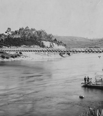
Digital images from film, taken as preservation copies, thanks to Margaret Thomas. 8 photos of various machines/people, getting stuck with a load of clay pipes. Can you name any of these people or machines?! If you know any of this equipment or the people, please let us know, thanks. And we appreciate those of you who commented with more information on this project when we previously posted others. More photos of this project can be seen in these Community Archives under entry CWA.026.060.005 The caption from the front of the film clip states, "Film Footage of Tuatapere Local Activities Filmed by Rhon & Gwyn Davies 1950s-60s": Many local contractors and men from different district businesses were employed over many years to form this new Lake Hauroko Access Road, which according to a news article from 6 April 1964, was officially opened in on 4 April 1964 - as an "All Weather" road. This road was a feat of the south western districts volunteer efforts and one that due to the determination of those driving the project, saw a lot of much needed aid in costs from both local council and government. From the 1960's locals were adamant about putting a new "all weather access" road through to Hauroko, continuing from the Lilburn Valley Rd. These people were passionate about their cause, and formed the 'Lake Hauroko Access Committee'. This road was not a Government or WCC (Wallace County Council) paid effort, although both gave some funds to the project. A large chunk of the money was fundraising efforts to have the road completed, as well as the locals also participating in working bees, where around 30 persons would turn out with both machinery and manpower, to assist with making culverts and other work, all the while Wilf McKercher with his big D6 bulldozer worked on ahead, ensuring the route the volunteers needed take was already cleared. George Horrell kindly contacted us when he saw the first lot of photos of this project and said his grandfather Herb was also involved in the project and he used their D2 bulldozer which is still in the family. The Horrell family have recently also donated their own photos of this Hauroko Road project which will soon be put up in the archives for you all to see and enjoy. If any more of you have other photos can you please consider loaning these to us for digitising and returning so we can build up a larger story of this. The first series of these photos are rather amusing, with a large truck of clay pipes very obviously stuck in deep mud, and a bulldozer being called in to push it back out. You can clearly see the name "Hauroko" across the back of the truck of pipes. In the second series of these photos we can see more clay pipes being tractored across a stream with what appears to be either a 'ballast' of men and children, or people who did not want to get their boots muddy that day. Does anyone have any more information? The lake and part of the access road sit within the Fiordland National Park's jurisdiction, they were instrumental with funds for access. As far back as 1960, the Fiordland National Park's Board had acknowledged the access issues at Lake Hauroko and said finance was a "limiting factor." The road into Lake Hauroko would be of great benefit to the National Park itself, its Rangers, visitors and wildlife enthusiasts, hunters, fishers and eventually a wide array of tourists, all coming to view Aotearoa NZ's deepest lake, while also trying to avoid the largest swarms of sandflies! In early 1964 the news of the day carries these below costs to date: £7,000 about paid out so far, comprising the following - £2,200 raised so far by 'Lake Hauroko Access Committee' and others, £1,000 from National Parks Authority, £3,900 subsidy from Government for the Wallace County works, It was expected at this point that the total costs for the access road would be in the vicinity of £8,000 including what had already been paid, with the committee pursuing a total of $3,000 to ensure completion. It was said at the time that whether or not the road could be gravelled on completion, depended entirely on the availability of extra funds for this. This new road was a culmination of years of hard work. Varying news articles and history accounts about the road building show a lot of local effort, and some of the photos clipped from the video back all this up. The ground appears to be very wet and swampy, with streams to ford and then drainage pipes to lay. Fascinating photos of tractors up to the top of their wheels in mud seem to be the order of the day. Little do the travelling tourists of today know the amount of long hours of labour that went into making that "gravel track" some of them complain about, and quite a few even "fly" off as they don't slow down as requested!! The road was formed in two parts, the first section from the end of Lillburn Valley road was done earlier on, it was a flat section of about 2 and a half miles (or approx 4km) that was known as Davis Flat. This was built by the WCC or Wallace County, we believe partly by Steve Kokay who was involved in earlier road building efforts on previous access roads into Hauroko. He ran a mobile gravel plant which worked across the Waiau and even futher afield into the whole of WCC or Wallace County Council district and will still be remembered by many of the older residents around the local area and even further afield. Steve became a very successful roading contractor, (see his plant pictured in the archive collection on this site under CWA.198.138.002), many of the country roads across the huge Western Southland district and even over into the Central Western Southland district, were constructed by him and his men, who were housed in removable huts at their work sites. Another contractor hugely involved in the project of the second half of the access road under the Committee, was 'Wilf' McKerchar, and it would be fabulous if more people could come forward with information about him and his business, and also his role in assisting with the road. I have not yet managed to find if Wilf was a paid contractor or did this as a voluntary effort, or if time/costs were paid by the roading committee. Wilfred Gillander (previously known as "Mac") McKerchar, was alive from 23rd Oct 1909 - 14th April 1995, and his wife was Annie McKerchar. The second and later formed part of the access road was about 4 miles or approx 6.5km through dense bush, streams and virtual swamp, and it was this section that the Lake Hauroko Access Committee focused their efforts on, with their working bees and fundraising as needed to get the job done. The size of the project when looking through the film, seems daunting and it's credit to our forebears for their perseverance with this. During the building of this last section of the road, a local outdoor living bushman who occupied a self-built hut near the lake, known as 'Wingy' Henderson (as he had only one arm) had to be moved on and his wee homestead dismantled. Photos and information on this is coming soon in another new entry for these archives. The road was duly complete although not in the timeframe originally hoped, as many visitors would take a trip to the site to find it not yet complete and many extensions of time were printed in the newspapers. CREDIT: The bulk of the information contained above and the preservation copy of this old video were provided thanks to the “Kokay Family Collection” also information gleaned from old newspaper reports kept by the family and others available at PapersPast. More information about this access road will be added shortly. In the meantime, please share your memories and any stories of it you know, and let us know if you have any more photos please. You can do this by adding a comment about it, at the bottom of the image page.
Ngā whakamārama
Details
-
Title
Wallace County District Infrastructure: Lake Hauroko Access Road - the saga of getting stuck with a load of pipes!
-
Maker
Davies, Gwyn & Rhon
-
Date made
Pre 1966
-
Subject
Business & Industry, Machinery & Equipment, Kokay, Waiau District, Wallace County, Wallace County Council, Road & Bridge Building, Lake Hauroko, McKerchar, 'Woolf', Working bee's, Fundraising efforts, Community Projects, National Parks' Authority, Fiordland National Park Board, Davies, Gwyn & Rhon
-
Additional information
Preservation Copy - Digital only images in archive
-
Rights
All rights reserved
-
View source record for this item
Kei hea tēnei taonga?
Where is this item held?
-
Additional information including high resolution images may be available.
-
Location
Main Rd, Tūātapere, next to the old Railway Station. We also belong to the internationally recognised 'Safe Space Alliance'.
Whare taonga | Organisation
Central & Western Murihiku Southland Archive
Ngā here ki runga i ngā whakaahua o tēnei taonga?
What can you do with images of this item?
-
You must check with Central & Western Murihiku Southland Archive to confirm terms of use and any attribution requirements, but this is our understanding:
-
Use for private study, research, criticism, review, or education
NZ Copyright law allows for the use of copyrighted works in specific circumstances. Consider what you can do under copyright law.
-
No sharing
You can't share this image without futher permission.
-
No modifying
You can't modify, remix or add to this image without further permission.
-
No commercial use
You can't use this image to make money.
-
Text adapted with permission from Te Papa and Digital NZ
Tāpirihia he kōrero anō
Improve this record
-
Can you help us? Share names, details and stories to help enrich the collection.